This week's blog post is based on an article titled "Unmanned Aerial Vehicles (UAVs) and Artificial Intelligence Revolutionizing Wildlife Monitoring and Conservation". This article highlights the importance and necessity of using unmanned aerial systems' technology to enhance military and civilian applications. This article gives us an insight on how unmanned aerial system technology paired with artificial intelligence can significantly improve current methods in any given operation; in this case, wildlife monitoring.
Obtaining wildlife population estimates can be difficult and time consuming. The most common techniques used to estimate wildlife population include remote photography, camera traps, tagging, GPS collaring, GPS sampling, scat detection dogs, and surveys performed on foot. These techniques can be very inefficient and worse yet, inaccurate. Nevertheless, these techniques have contributed to the protection and conservation of wildlife for many years. Current monitoring techniques are also limited due to low wildlife population densities, large geographic ranges, elusive behavior, inaccessible habitat, and wildlife's sensitivity to disturbance.

The advancement of unmanned aerial systems and artificial intelligence have created a new opportunity to conduct wildlife surveys. Although the use of UAS in wildlife monitoring can be affected by current laws, and public perception. Unmanned aerial systems have demonstrated to be more efficient when conducting these operations than manned platforms. Among the advantages of using unmanned systems is risk reduction, increased safety, lower cost, and reduced logistics, and low disturbance rates. The article describes a study in which unmanned aerial systems are used with advanced detection sensors. The purpose of the study was to achieve automatic thermal object detection, acquisition, classification, and tracking of wildlife in a specified area to obtain a population estimate.
1. Load templates
2. Process templates
3. Search for each template in the video frame
4. Assign coordinates
5. Create a mask using coordinates
6. Logical operation with the mask
7. Pixel intensity threshold
8. Tracking
9. Counting
10. Last frame loop (If the process is unsuccessful, the algorithm re-starts in step three)
The validation test was focused on the detection, tracking, and classification of Koalas, a marsupial specie whose population has been in declined in the last few years. The experiment took place between 7:00 am and 8:00 am, thought to be ideal for the temperature difference in Koala species. RGB video as well as thermal video was acquired using the UAS in autonomous mode which had a predefined mission which commanded it to conduct a lawn mower pattern search.
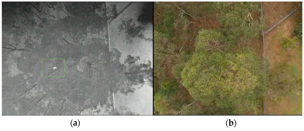
The study was successful in detecting various types of Koala in the specified area. The GPS was able to display the location of all specified targets. This new advanced capability will assist advocates in determining the population distribution and abundance of any species. This will give developers and stakeholders better situational awareness on the impact that new constructions could have on the habitat of endangered species. The algorithms used can be adjusted to meet specifications for any type of animal, for a specific size, and even a specific thermal signature. As you can see, this new technology enhances current processes and provides more accurate population estimates in regards to wildlife conservation.
References
Gonzalez, L., Montes, G., Puig, E., Johnson, S., Mengersen, K., & Gaston, K. (2016). Unmanned Aerial Vehicles (UAVs) and Artificial Intelligence Revolutionizing Wildlife Monitoring and Conservation. Sensors, 16(1), 97. MDPI AG. Retrieved from http://dx.doi.org/10.3390/s16010097

No comments:
Post a Comment